Bristlecone Pine — spanning the species Pinus longaeva, Pinus aristata, and Pinus balfouriana — living up to more than 4,800 years old, stands as the oldest non-clonal organism on Earth. These resilient trees are sculpted by millennia of wind and snow, quietly witnessing the collapse of empires and surviving through both ice ages and volcanic eruptions. Thriving in harsh adverse conditions, the very environment that seems meant to destroy them, they have mastered the art of endurance.
First conceptualized by David “Barney” Barnett after passing through a grove of bristlecone along the Colorado Trail, Bristlecone-Geo is represented by that resilience.

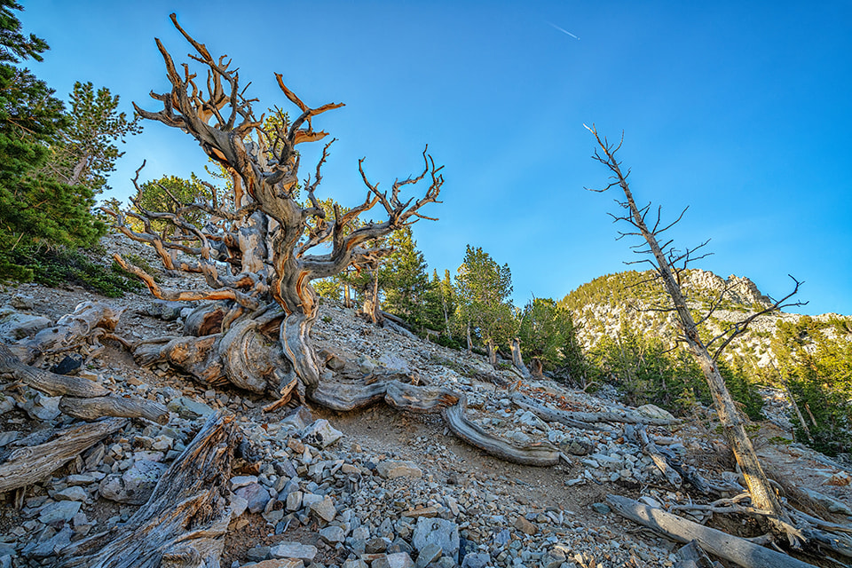
Bristlecone pine found along the Colorado Trail (photo by author, 2001)
The gnarled, weathered silhouettes of the bristlecone pine are often portrayed as iconic symbols of natural heritage, frequently woven into the fabric of artistic culture.
Professional Services

Founder, Bristlecone-Geo — Cedar Mesa, Utah (2026).
David “Barney” Barnett
David is a Certified Professional Geologist registered in good standing with the American Association of Professional Geologists. David received a Bachelor of Science in Geology from Fort Lewis College in 1991, a Professional Certificate Degree in Geographic Information Science from Metropolitan State University in 2001, and has over 35-years applied project experience in the Great Basin, Colorado Plateau, Alaska, and the Rocky Mountain Cordillera.
Select Professional Experience:
Project Geologist — Mineral Remote Assessment (Remoteness Letters)
- Green Ranches Conservation Easement – Moffat County, Colorado
- Berrien Ranch Conservation Easement – Park County, Colorado
- Box 6 Ranch Conservation Easement – Park County, Colorado
- Taylor Ranch Conservation Easement – Fremont County, Colorado
- Great Divide Ranch Conservation Easement – Moffat County, Colorado
- Thirtynine Mile Mountain Ranch Conservation Easement – Park County, Colorado
- Lower Spring Ranch Conservation Easement – Moffat County, Colorado
- Vallie Ranch Conservation Easement – Fremont County, Colorado
- Windy Ridge Ranch Conservation Easement – Boulder County, Colorado
- Bull Springs Ranch Conservation Easement – Teller County, Colorado
- La Dolce Vita Ranch Conservation Easement – Park County, Colorado
- Vickerman Ranch Conservation Easement – Custer County, Colorado
- Twin Pines Ranch Conservation Easement – Boulder County, Colorado
- Forest Lakes Open Space Park Conservation Easement – El Paso County, Colorado
Project Geologist — Mineral Potential Reports
- Upper Uncompahgre District Mineral Property File Compilations (critical minerals)
- Wet Mountains Mineral Potential Property File Compilations (critical minerals)
- Unaweep-Paradox Mineral Potential Property File Compilations (critical minerals)
- Escalante Ranch Federal Mineral Potential Report – Uncompahgre National Forest
- Locke Park Federal Mineral Potential Report – San Isabel National Forest
- Mt. Emmons Federal Mineral Potential Report – Gunnison National Forest
- Wagon Tongue Federal Mineral Potential Report – San Isabel National Forest
- Willow Creek Federal Mineral Potential Report – Roosevelt National Forest
- Montava Mineral Assessment Report (coal-only) – Larimer County, Colorado
- Gold Prince Mine Mineral Assessment Report – Cochise County, Arizona
- Alaska-Yukon Generative Mineral Assessment Property File Reviews
- Stuyahok Prospect Mineral Potential Report – Marshall District, Alaska
- Donlin Creek Prospect Mineral Potential Report – Aniak District, Alaska
Project Geologist — Baseline Documentation Maps & Reports
- Mt. Tom Open Space Park – Jefferson County, Colorado
- Colorado Headwaters – Granby Highlands Open Space Trail Maps
- Santa Fe Trail Ranches Community Wildfire Protection Plan
- Fording River Mine Extension (fugitive methane) – British Columbia
- Murray River Mine (fugitive methane) – British Columbia
- North Park Natural Gas Environmental Assessment Project, Colorado
- McDermitt Caldera Lithium (DOGAMI permitting) – Oregon
- Clayton North Lithium Prospect Maps – Nevada
- Waggener Farm Conservation Easement GIS & Cartography
- Lewis Farm Conservation Easement GIS & Cartography
- Forest Lakes Conservation Area Maps
- Fisher Peak State Park Habitat Characterization
- Mill Creek Recreational Trail Corridor – Moab, Utah
- Glade Run Recreational Area NEPA – Farmington, New Mexico
- Bonneville Shoreline Trail Alignment Verification – Davis County, Utah
- Glen Lake Cunningham Reservoir Trail Alignment Verification – Omaha, Nebraska
- Mill Creek Recreational Trail Alignment Verification – Bountiful, Utah
- Red Hill Special Recreation Management Area Trails – Carbondale, Colorado
- Bonneville Shoreline Trail Alignment Verification – Salt Lake County, Utah
- Great Divide Trail Alignment Verification – Salt Lake County, Utah
- Tamarisk Riparian Restoration Characterization, Colorado
- Piceance Basin Natural Gas Environmental Impact Studies
- Garnet Mesa Electric Transmission Corridor EIS
- Dome Plateau Vibroseis Environmental Impact Study
- Uncompahgre Plateau Restoration Project
Geologic Cartographer — Colorado Geological Survey
- OF-09-02 Divide Quadrangle
- OF-09-04 Fruita Quadrangle
- OF-12-01 Antero Reservoir Quadrangle
- OF-13-01 Hayden Gulch Quadrangle
- OF-14-15 Hotchkiss Quadrangle
- OF-15-05 Hayden Quadrangle
- OF-15-07 Paonia Quadrangle
- OF-15-08 Lazear Quadrangle
- OF-16-06 Roubideau Quadrangle
- GQ-397 Fort Lupton Quadrangle (GeMS conversion)
- GQ-398 Hudson Quadrangle (GeMS conversion)
- GQ-725 Hanover NW Quadrangle (GeMS conversion)
- MF-842 Woodland Park Quadrangle (GeMS conversion)
- MF-761 Montrose 1° x 2° Quadrangle (GeMS conversion)
- OF-22-13D Delta 30×60 Minute Quadrangle (GeMS conversion)
- OF-22-16D Montrose 30×60 Minute Quadrangle (GeMS conversion)
- OF-23-04 Milton Reservoir Quadrangle (GeMS)
- OF-24-03 Severance Quadrangle (GeMS)
- OF-25-01 Brush West Quadrangle (GeMS)
- OF-26-01 Brush East Quadrangle (GeMS)
GIS & Geospatial Science —
- Riverside Cemetery GIS – Hotchkiss, Colorado
- Cedar Hill Cemetery GIS – Paonia, Colorado
- Bethlehem Cemetery GIS – Paonia, Colorado
- San Luis Valley Telephone Authority E911
- Saguache County Assessor and Land Use Departments
- Region 10N Broadband Internet Infrastructure GIS Update
- Mosca Wastewater Treatment Plant (WWPT) GIS
- SFTR Community Wildfire Protection Plan GIS
- Colorado Headwaters Land Trust Conservation GIS
- Las Animas County Assessor Office
- Grand Mesa Metropolitan District WWTP UAV imagery
- Town of Dinosaur WWTP UAV imagery
- Town of Nucla WWTP UAV imagery
- Rapid Creek Utility Corridor UAV Imagery
- Viscount Mining Corp – Silver Cliff Project UAV Imagery
- City of Ouray Master Plan GPS Inventory Survey
- Tamarisk Riparian Restoration Characterization
- Mesa County Assesssment Cartography (GIS)
- Orchard City Floodplain Map Conversions
- Mesa Land Trust Conservation GIS Database
- Black Canyon Regional Land Trust Conservation GIS Database
- El Paso Energy – Raton Basin Basemap Imagery
- Vermejo Park Ranch Basemap Imagery
- Town of Orchard City Planning Commission
- NRCS Ridgway Soil Survey Map Conversions
- Montrose County Assessment Map Conversions
Cartography Projects —
- Rio Grande County Weed District Maps
- Colorado Potato Certification Service Maps
- Alamosa School District Maps
- Gunnison Bluffs Open Space Trails Wayfinding
- Oakridge Open Space Trails Map – Oregon
- Lazy V Ranches Property Inventory Maps
- Legacy Properties Ranch Inventory Maps
- Tabeguache (Lunch Loop) Trails Wayfinding
- Colorado Trail Official Guidebook Maps, 10th Edition
- Grand Valley Trails (COPMOBA) Trail Maps
- West End Trails (COPMOBA) Trail Maps
- GJ Sentinel Ride Magazine MTB Trail Maps
- Palisade Plunge Trail Wayfinding
Education & Certification:
BSc. Geology, 1991 —
Fort Lewis College, Durango, Colorado
GIS Certificate, 2001 —
Metropolitan State University, Denver, Colorado
Certified Professional Geologist (CPG-11924) —
American Institute of Professional Geologists
Practical Geocommunication 3.0 — Geologize Ltd.
sUAS Remote Pilot – Federal Aviation Administration
Professional Affiliations:
American Institute of Professional Geologists
Four Corners Geological Society
Grand Junction Geological Society
Rocky Mountain Association of Geologists
Society of Economic Geologists
Volunteer:
Volunteers for Outdoor Colorado
Grand Valley Trails


