
The Dunmore Mine, located in Section 17, T.43.N, R.7W., N.M.P.M., Ouray County, Colorado, is situated on Silver Creek near the junction of Red Mountain Creek just above its junction with the Uncompahgre River. The descriptions of this and other mineral resources below are located within the Upper Uncompahgre District, an area defined as lying along Red Mountain Creek, below Ironton Flats and that part of Uncompahgre Canyon from its junction with Red Mountain Creek to Ouray.
Within the area, the geology transitions from steeply dipping Precambrian quartzites and slates of the Uncompahgre Formation to moderately tilted Paleozoic and Mesozoic sedimentary rocks, all capped by nearly horizontal Paleogene-aged volcanic conglomerates, tuffs, and breccias of the San Juan Formation. Paleozoic sedimentary rocks include the Late Devonian Elbert formation and Ouray limestone, the Mississippian Leadville limestone, and the Pennsylvanian Molas and Hermosa formations. The Precambrian rocks represent part of an east-west trending, uplifted fault block known as the
Sneffels Horst, which is bounded on the south by the Dunmore fault on the south and by the Ouray fault on the north. The tectonic history of the Sneffels Horst has had a profound influence on the geology in this region. From Ironton Park, north towards Ouray, the Paleozoic-Mesozoic section is absent and the San Juan Formation rests unconformably on the Uncompahgre Formation.
Economic mineralization within the district is distributed across the Uncompahgre formation, the Paleozoic-Mesozoic sedimentary formations, and the San Juan Formation, though the style of the deposits varies by host environment. Fault-controlled fissure veins are the predominant deposit type within both the Uncompahgre Formation and San Juan Formation. These veins consist mainly of a quartz matrix hosting pyrite, sphalerite, galena, chalcopyrite, native gold, argentiferous (silver-bearing) tetrahedrite, rhodochrosite, and barite. Localized variations occur within a few select veins, which contain tungsten-bearing ore shoots (typically huebnerite) or lead-silver sulfobismuthites such as alaskaite. Conversely, the ore deposits within the Paleozoic-Mesozoic strata occur as silver-lead replacement deposits localized within the upper portion of the Leadville Limestone.
Extending over two miles in length, the Dunmore fault and fissure zone spans both the Red Mountain Creek and Uncompahgre River valleys, is approximately 100 feet in width, strikes N. 75o W., and dips 80o SW. This zone extends from Precambrian quartzites into overlying breccias of the San Juan Formation, and has an approximate vertical offset of 4,500 feet. Locally, this fault and fissure zone extends from Precambrian quartzites into breccias of the San Juan Formation.
Mineral deposits found at the Dunmore Mine are some of the most complex and significant in the area because both vein- or chimney-type deposits are found here. Mineralization at other mines within the district and the surrounding region are either vein- or chimney-type deposits, but not both. Mineralization at the Dunmore Mine, and nearby Michael Breen Mine, include Paleogene veins with Precambrian wall rocks below the Paleogene volcanic rocks. This suggests that the Dunmore fault-controlled fissure zone served as a deep-seated conduit for ore-forming solutions which helped to deposit minerals along its length and into branching veins. Additional mines and prospects located along the fissure zone include the MacGregor, Yankee Lad, Chrysolite, North Star, Connie, Albert, Mountain Monarch, and potentially the Michael Breen.
Two main epochs of mineralization (including their respective suites of minerals) have been identified at the Dunmore lode:
Early Paleogene Epoch — Possibly of Late Cretaceous or Early Eocene age, produced a largely barren mineral assemblage. This stage is characterized by the presence of chalcedonic quartz, sericite, kaolin, and pyrite. It involved the development of pebble dikes and breccia chimneys within the lode.
- Quartz – SiO2
- Sericite – KAl2(AlSi3O10)(OH)2
- Kaolinite – Al2Si2O5(OH)4
- Pyrite – FeS2
Late Paleogene Epoch — Mineralization occurred after the deposition of the San Juan Formation and represents the most productive part of the lode. This epoch includes several stages of mineralization that formed distinct structures, such as a hematite chimney containing a copper shoot, a tungsten (huebnerite) chimney, compound base-metal fissure veins, and marginal branch veins.
- Hematite – Fe2O3
- Pyrite – FeS2
- Quartz – SiO2
- Chalcopyrite – CuFeS2
- Aikinite – CuPbBiS3
- Tetrahedrite – Cu12Sb4S13
- Galena – PbS
- Sphalerite – ZnS
- Wolframite – FeWO4
- Huebnerite – MnWO4
- Rhodochrosite – MnCO3
- Barite – BaSO4
- Calcite – CaCO3
- Fluorite – CaF2
- Sodium Chlorite – NaClO2
Available Production & Exploration History
The Dunmore Mine was developed across two primary levels at an altitude of 9,090 feet and 9,264 feet respectively. Each level contains approximately 1,000 feet of tunnel, connected by a raise. Surface infrastructure included two small buildings, two ore bins, and featured a 900-foot aerial tramway which transported ore from the lower workings to the Ouray Toll Road (later becoming U.S. Highway 550).
Although both tunnels initially followed a narrow quartz vein along the north wall of the Dunmore fissure zone, the majority of mining development shifted to the south wall, where the most productive ore bodies were located. Key areas of extraction included a tungsten ore shoot between the two portals that measured 8 to 20 feet wide and 40 to 50 feet long, as well as a copper chimney measuring 30 to 40 feet across located west of the upper portal. An additional hematite chimney in the lode was identified as a potential source of iron ore due to extensive replacement by specular hematite.
Ore from the Dunmore Mine was shipped for processing to either the Shenandoah-Dives mill at Silverton via the Rio Grande Southern Railroad or to the Banner-American Zinc mill at Ouray, a 120-ton-per-day custom flotation mill built in 1931. While production records are incomplete to permit for quantitative appraisal of the metalliferous mineral resources, many high-grade ore bodies representative of those which have been mined are assumed to remain undiscovered in the area.
1917 – Eight tons of ore shipped to the smelter contained 0.50 ounces of gold, 194 ounces of silver, and 509 pounds of copper.
1926 – Sample analysis report indicated 24% copper, 20% iron, 0.10% lead, 0.63% zinc, 11.8 oz. silver. and 0.05 oz. gold per ton.
1937 – Production reached 50 to 60 tons per day, including considerable development of base-metal and tungsten ores.
1938 – Production included approximately 300 tons of huebnerite (tungsten) ore yielding about 300 units of 60 to 70 percent WO3.
1940 – Onsite fieldwork completed by the U.S. Geological Survey
1941 – Dunmore Lode mining claim was patented (Patent No. 1110731, Mineral Survey 20608)
1951 – Listed as operating mine in Ouray County by Colorado Bureau of Mines.
1952 – Ten diamond core holes totalling 1,000 combined feet, were drilled to explore downward extension of the hubnerite-bearing breccia pipe. All holes were drilled from one station on the lower mine level. While siliceous and breciated vein material was intersected, no tungsten of commercial value was located.
1953 – Following drilling results, the U.S. Bureau of Mines estimated ore reserves as 4,600 tons at 0.80% WO3 Measured and Indicated.
2008 – Dunmore (MS-20608) and Yankey Lad (MS-2131) patented lode claims deeded to the United States (COC 71101).
Maps, Cross Sections and Photographs


(modified from Silver, 1946)
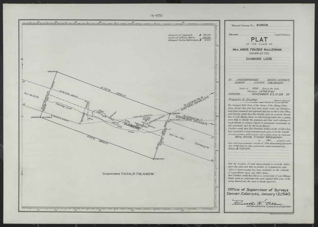
(BLM GLO, 1940)

(Burbank and Pierson, 1953)
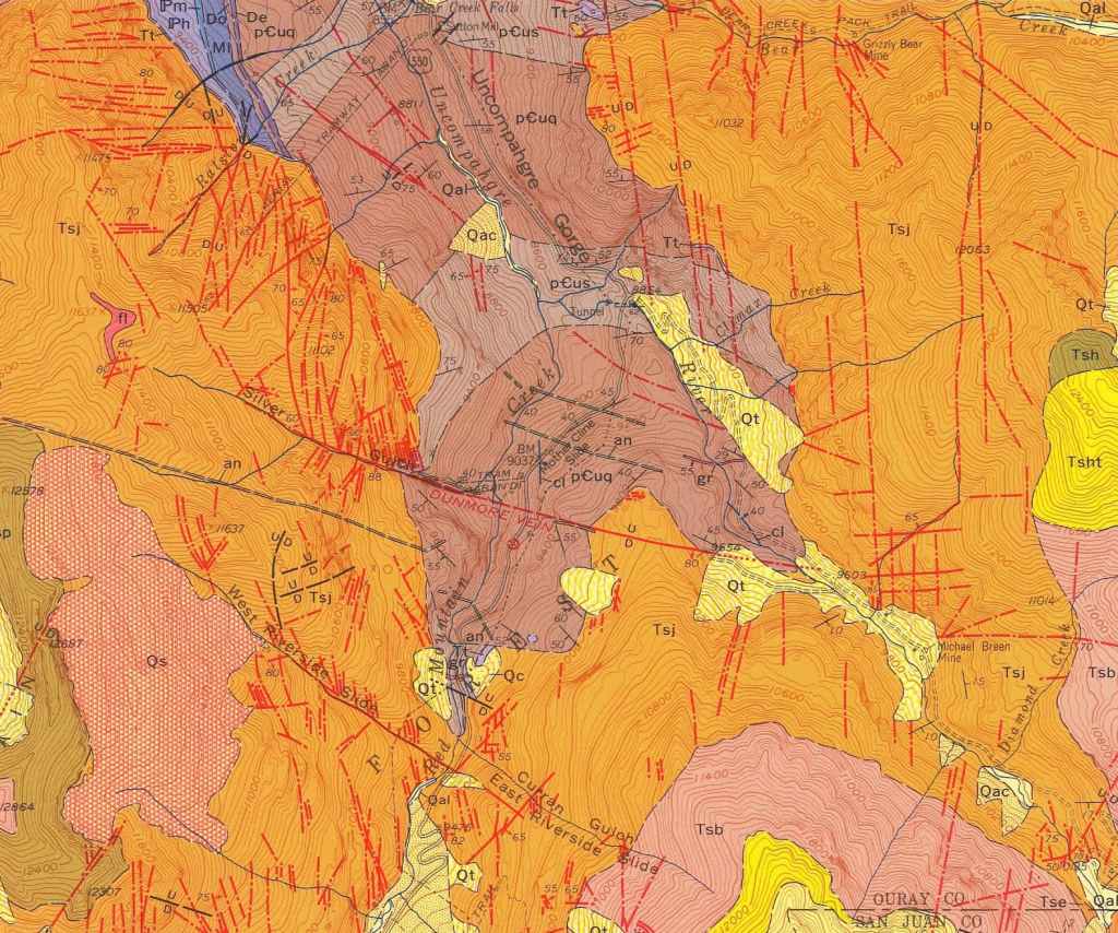
(Burbank and Luedke, 1964)

(Cross, et al., 1905)
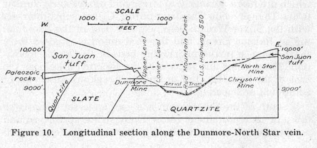
(Kelley, 1946)
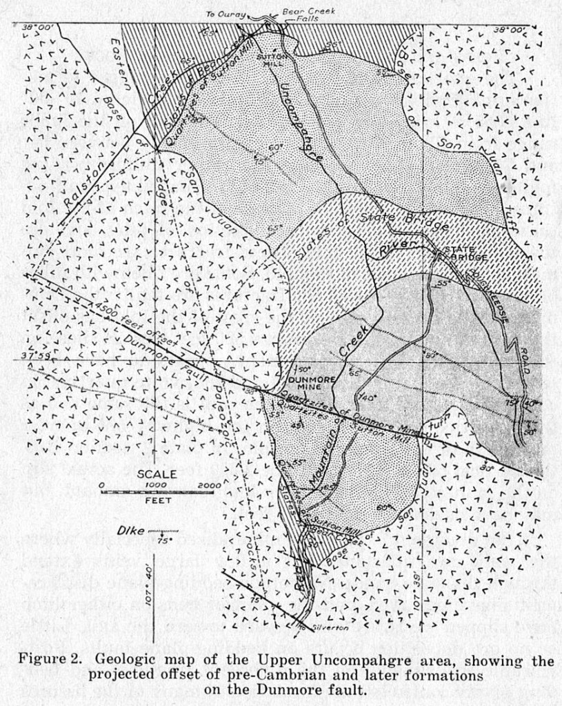
(Kelley, 1946)
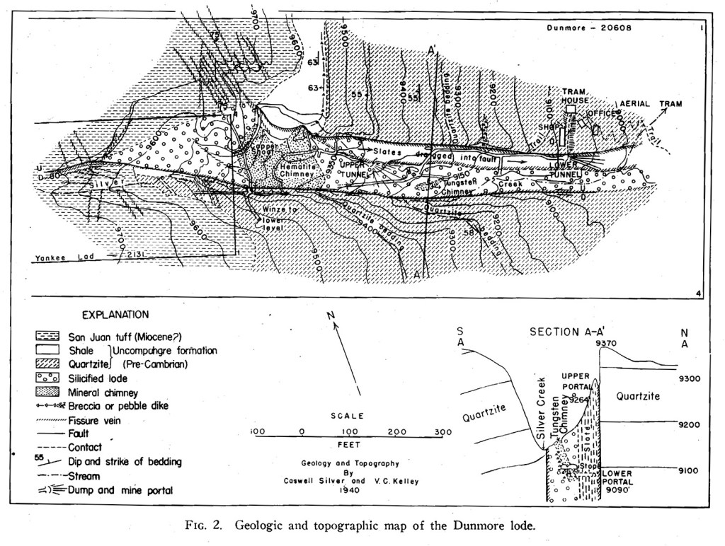
(Kelley and Silver, 1946)

(Silver, 1946)
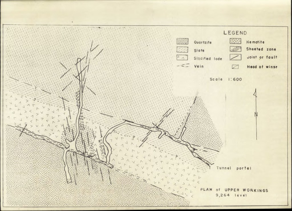
(Silver, 1946)
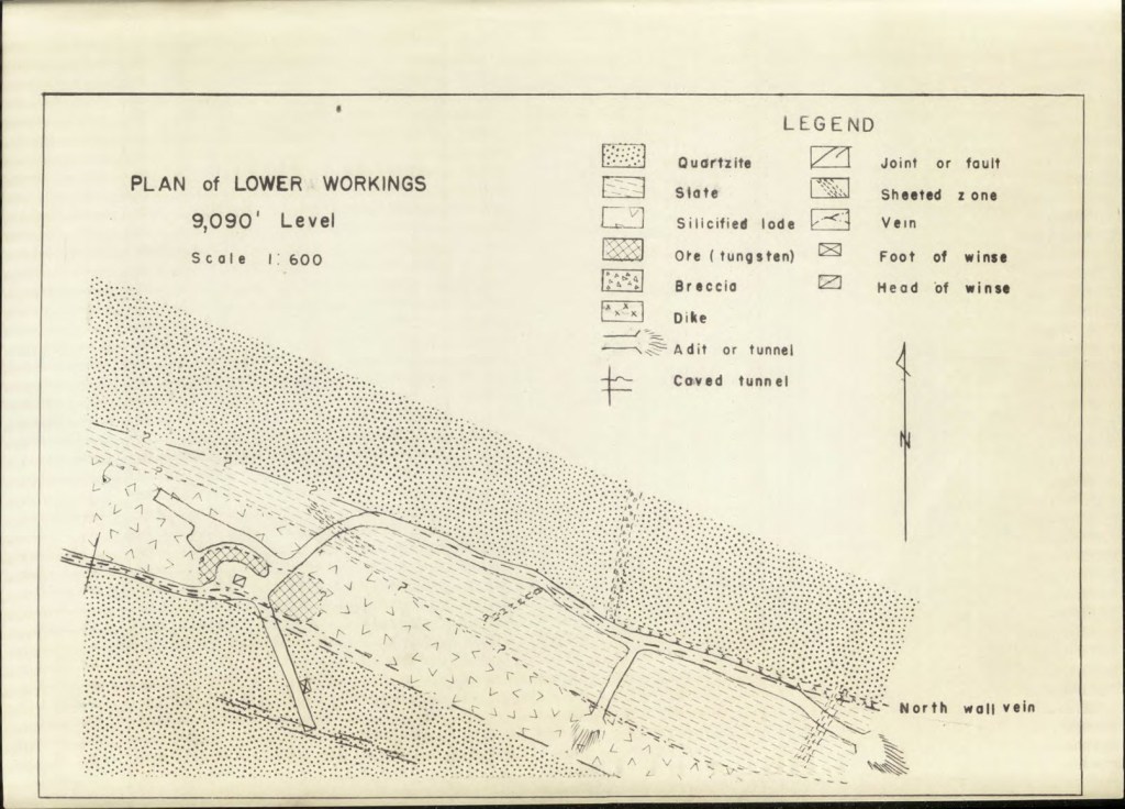
(Silver, 1946)
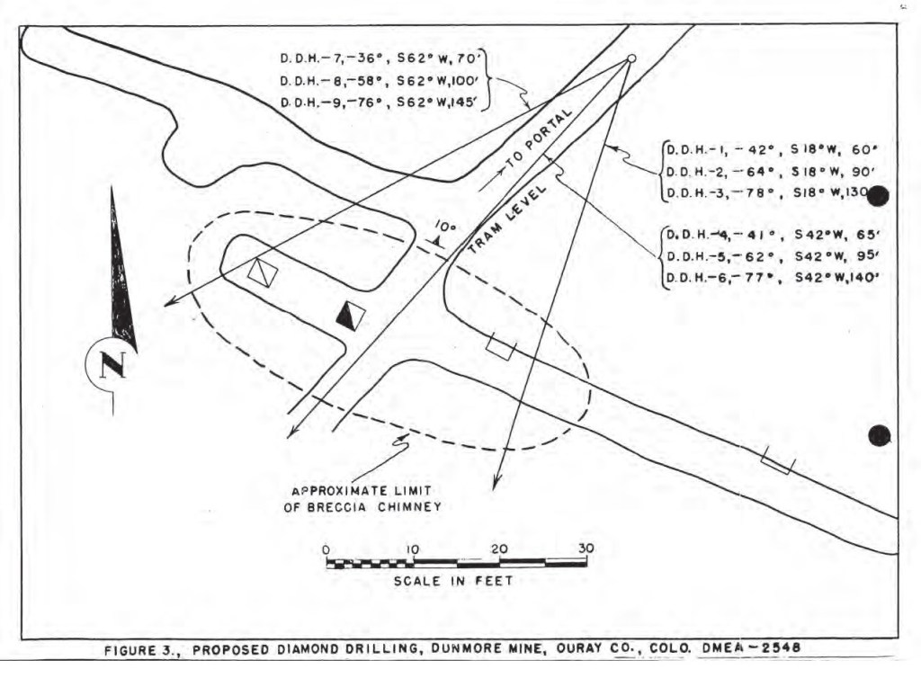
(DMEA File No. 2548)
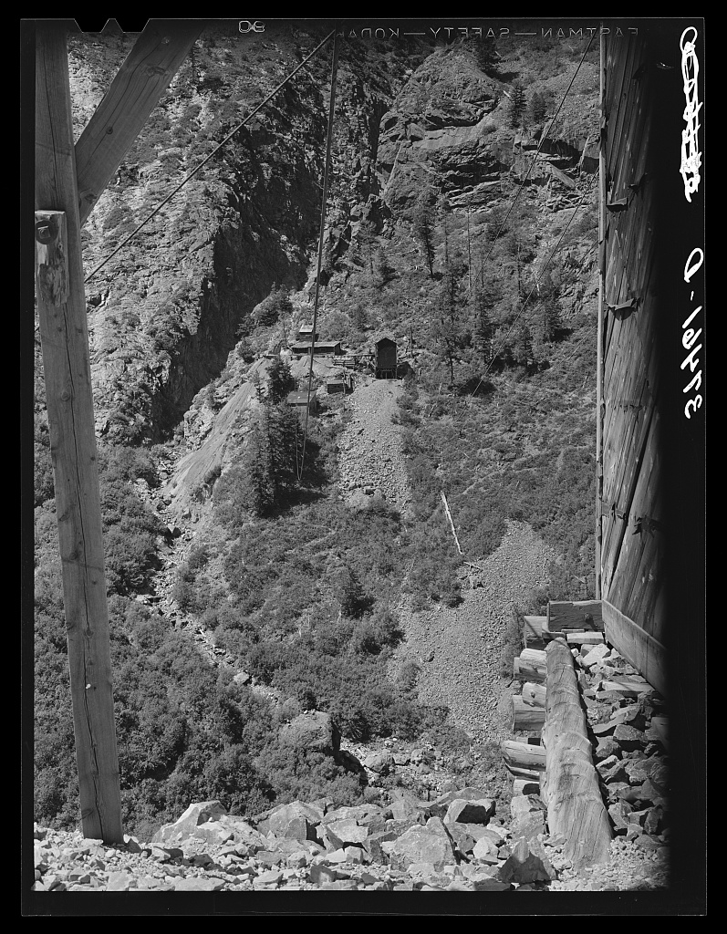
(Lee Russell, 1940)
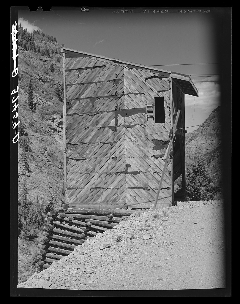
(Lee Russell, 1940)
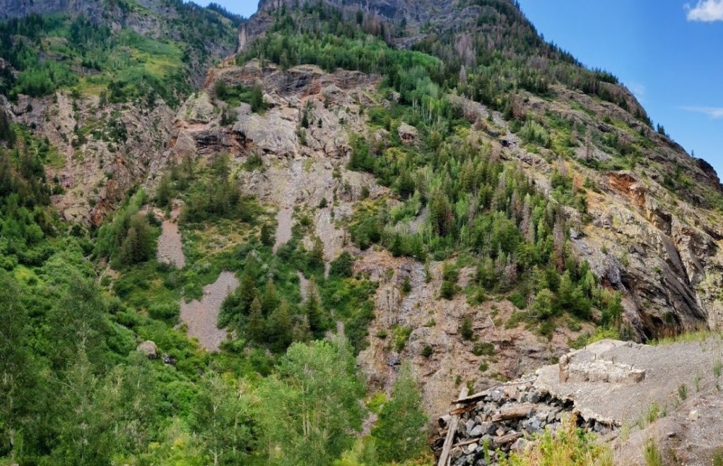
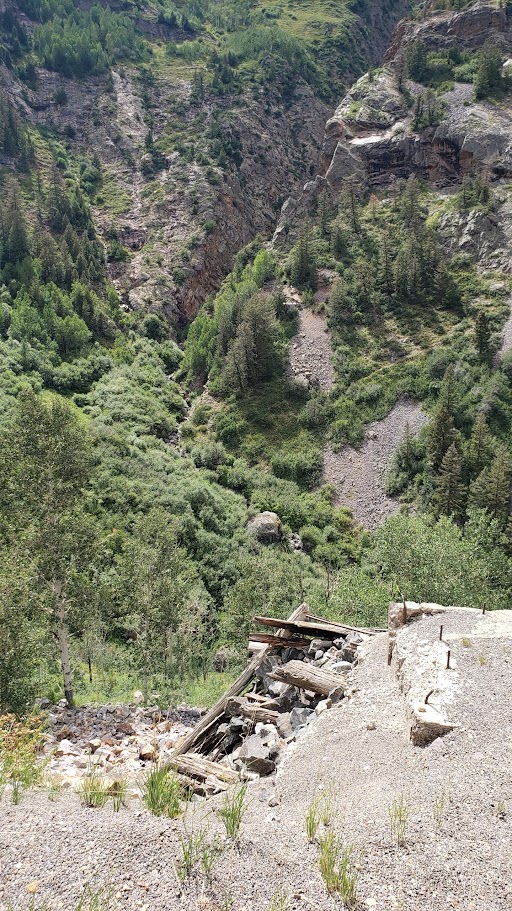
alongside Highway 550 (photo by author, 2024).

(Lee Russell, 1940)

(Lee Russell, 1940)
References
Belser, C., 1956, Tungsten Potential in the San Juan Area, Ouray, San Juan, and San Miguel Counties, Colorado: Bureau of Mines Information Circular 7731, pp. 4-6. https://bit.ly/4dYsfLM
Burbank, W.S., and Luedke, R.G., 1964, Geology of the Ironton quadrangle, Colorado: U.S. Geological Survey Geologic Quadrangle 291 (GQ-291), 1 map. https://doi.org/10.3133/gq291
Burbank, W.S., and Pierson, C.T., 1953, Preliminary results of radiometric reconnaissance of parts of the northwestern San Juan Mountains, Colorado: U.S. Geological Survey Circular 236 (CIR-236), 11 plates. https://doi.org/10.3133/cir236
Cross, W., Howe, E., and Ransome, F.L., 1905, Silverton folio, Colorado: U.S. Geological Survey Folios of the Geologic Atlas 120, Report: 34 p.; 6 Plates: 17.55 x 21.01 inches or smaller, https://doi.org/10.3133/gf120
Fischer, R.P., Luedke, R.G., Sheridan, M., and Raabe, R., 1968, Mineral resources of the Uncompahgre primitive area, Colorado: U.S. Geological Survey Bulletin 1261, 91 p., 3 plates. https://doi.org/10.3133/b1261C
Kelly, V.C, 1946, Geology, Ore Deposits, and Mines of the Mineral Point, Poughkeepsie, and Upper Uncompahgre Districts, Ouray, San Juan, Hinsdale Counties, Colorado: Colorado Scientific Society Proceedings, Volume 14, No. 7, pp. 362-365. https://coloscisoc.org/proceedings-of-the-css-vol-14/
Kelley, V.C. and Silver, C., 1946, Stages and Epochs of Mineralization in the San Juan Mountains, as shown at the Dunmore Mine, Ouray, Colorado: Society of Economic Geologists, Economic Geology, v. 41, pp. 139-159. https://doi.org/10.2113/gsecongeo.41.2.139
Russell, Lee, 1940, Library of Congress Prints and Photographs Division. https://bit.ly/4xyCheg
Silver, C., 1946, Geology and Ore Deposits of the Dunmore Mine, Ouray County, Colorado: University of New Mexico unpublished thesis, 185 p. https://digitalrepository.unm.edu/eps_etds/213
U.S. Bureau of Land Management, General Land Office Records: Survey Plats & Field Notes (Colorado). https://glorecords.blm.gov/
U.S. Geological Survey, Defense Minerals Exploration Administration (DMEA): Historical Files from Federal Government Mineral Exploration-Assistance Programs, 1950 to 1974. https://pubs.usgs.gov/ds/1004/ds1004_co.htm

Leave a Reply
You must be logged in to post a comment.