Geoscience is often a crucial element for efficient resource management of natural resource projects. Bristlecone-Geo assists landowners, extractive resource industry, local government, land appraisers, and land trusts through providing qualified geoscience research, mapping, and reporting services. Keeping the audience in mind, our reports are written to provide the rationale necessary to substantiate informed decisions for decision makers.
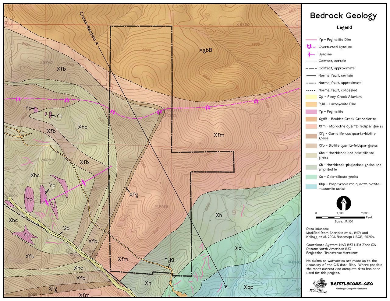
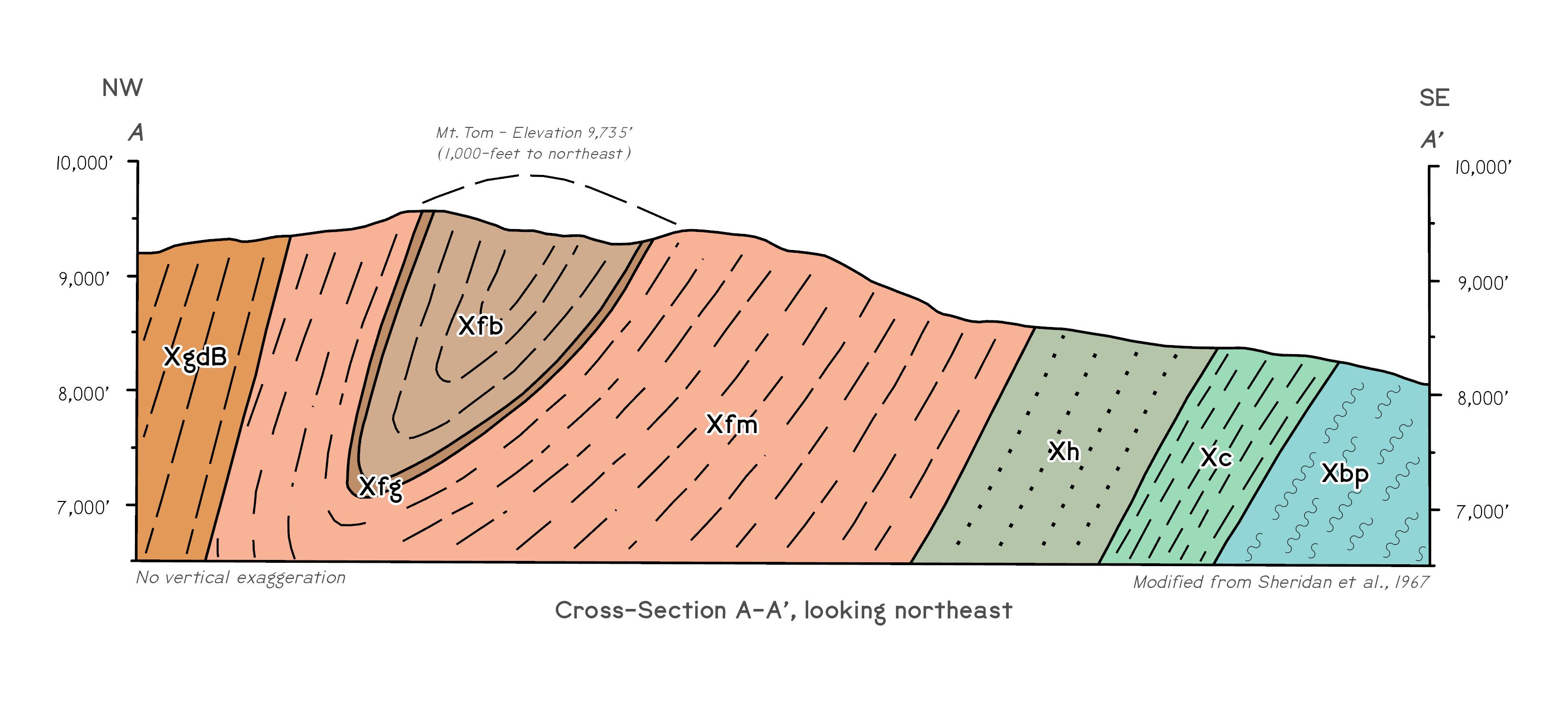
From recent mapping to historic map conversions, Bristlecone-Geo also crafts geologic maps, cross sections, stratigraphic columns, and other illustrations for baseline documentation and mineral assessment reports.
Bristlecone-Geo has prepared dozens of geoscience, mineral assessment reports, and remoteness letters for baseline studies. Our reports are prepared in accordance with classification systems developed by the BLM, USFS, and USGS by a Certified Professional Geologist.
Bristlecone-Geo’s geoscience services include:
- Land Status Research
- Mineral Potential Reports
- Mineral Assessment Reports
- Mineral Remote Assessment
- Remoteness Letters
- Severed Mineral Research
- Mineral Potential Property File Compilation
- Geologic Hazard Baseline Reports
- Historic Mineral Development Research
- Mining and Mineral Claim Mapping
- Geologic Field Mapping
- GPS Inventory Surveys
- Geologic Cartography
- Geologic Illustration
- Geologic Map Schema (GeMS) Contractor


Representative Geoscience Projects
Mineral Remote Assessment (Remoteness Letters) —
Bristlecone-Geo assists landowners and land trusts by providing qualified mineral resource reports for land appraisal and baseline conservation easements. Bristlecone-Geo has helped conserve over 42,500 acres in Colorado & Kansas.
- Western Gateway Park – Cañon City, Colorado
- 3 B Messenger Ranch – Kingman County, Kansas
- Woolfolk Ranches – Comanche County, Kansas
- Green Ranches – Moffat County, Colorado
- Berrien Ranch – Park County, Colorado
- Box 6 Ranch – Park County, Colorado
- Taylor Ranch – Fremont County, Colorado
- Great Divide Ranch – Moffat County, Colorado
- Thirtynine Mile Mountain Ranch – Park County, Colorado
- Lower Spring Ranch – Moffat County, Colorado
- Vallie Ranch – Fremont County, Colorado
- Windy Ridge Ranch – Boulder County, Colorado
- Bull Springs Ranch – Teller County, Colorado
- La Dolce Vita Ranch – Park County, Colorado
- Vickerman Ranch – Custer County, Colorado
- Montava Planned Community – Larimer County, Colorado
- Twin Pines Ranch – Boulder County, Colorado
- Forest Lakes Open Space – El Paso County, Colorado
Baseline Documentation Reports —
- Mt. Tom Open Space Park – Jefferson County, Colorado
- Colorado Headwaters – Granby Highlands Open Space
- Santa Fe Trail Ranches Community Wildfire Protection Plan
- Fording River Mine Extension (fugitive methane) – British Columbia
- Murray River Mine (fugitive methane) – British Columbia
- North Park Natural Gas Environmental Assessment Project, Colorado
- McDermitt Caldera Lithium (DOGAMI permitting) – Oregon
- Clayton North Lithium Prospect Maps – Nevada
- Waggener Farm Conservation Easement GIS & Cartography
- Lewis Farm Conservation Easement GIS & Cartography
- Forest Lakes Conservation Area Maps
- Fisher Peak State Park Habitat Characterization
- Mill Creek Recreational Trail Corridor – Moab, Utah
- Glade Run Recreational Area NEPA – Farmington, New Mexico
- Bonneville Shoreline Trail Alignment Verification – Davis County, Utah
- Glen Cunningham Reservoir – Omaha, Nebraska
- Mill Creek Open Space Trails – Bountiful, Utah
- Red Hill Special Recreation Management Area – Carbondale, Colorado
- Bonneville Shoreline Trail Alignment Verification – Salt Lake County, Utah
- Great Divide Trail Alignment Verification – Salt Lake County, Utah
- Tamarisk Riparian Restoration Characterization – Mesa County, Colorado
- Piceance Basin Natural Gas NEPA projects
- Garnet Mesa Electric Transmission Corridor EIS
- Dome Plateau Vibroseis EIS
- Uncompahgre Plateau Restoration Project NEPA
Federal Mineral Potential Reports —
- Escalante Ranch – Uncompahgre National Forest
- Locke Park – San Isabel National Forest
- Mt. Emmons – Gunnison National Forest
- Wagon Tongue – San Isabel National Forest
- Willow Creek – Roosevelt National Forest
Private Mineral Potential Reports —
- Dunmore Mine Property File Compilation – Ouray County, Colorado
- Unaweep-Paradox Property File Compilations – Colorado & Utah
- Gold Prince Mine Mineral Assessment Report – Cochise County, Arizona
- Alaska-Yukon Generative Mineral Assessment Property File Reviews
- Stuyahok Prospect Mineral Potential Report – Marshall District, Alaska
- Donlin Creek Prospect Mineral Potential Report – Aniak District, Alaska
Geologic Maps & Illustration —
Together with Pangaea Geospatial, Bristlecone-Geo has provided ongoing geologic map support to the Colorado Geological Survey (CGS) since 2008. Utilizing authoring geologist’s field notes and sketches, project elements include the development of geologic cross sections, correlation of map units, and other illustrations. CGS geologic map projects are partially funded by the USGS National Cooperatibe Geologic Mapping Program. Beginning in 2020, we have transitioned map development to the USGS Geological Map Schema (GeMS), a process which standardizes digital geologic map publications across the United States.
- OF-09-02 Divide Quadrangle
- OF-09-04 Fruita Quadrangle
- OF-12-01 Antero Reservoir Quadrangle
- OF-13-01 Hayden Gulch Quadrangle
- OF-14-15 Hotchkiss Quadrangle
- OF-15-05 Hayden Quadrangle
- OF-15-07 Paonia Quadrangle
- OF-15-08 Lazear Quadrangle
- OF-16-06 Roubideau Quadrangle
- GQ-397 Fort Lupton Quadrangle (GeMS conversion)
- GQ-398 Hudson Quadrangle (GeMS conversion)
- GQ-725 Hanover NW Quadrangle (GeMS conversion)
- MF-842 Woodland Park Quadrangle (GeMS conversion)
- MF-761 Montrose 1° x 2° Quadrangle (GeMS conversion)
- OF-22-13D Delta 30×60 Minute Quadrangle (GeMS conversion)
- OF-22-16D Montrose 30×60 Minute Quadrangle (GeMS conversion)
- OF-23-04 Milton Reservoir Quadrangle (GeMS)
- OF-24-03 Severance Quadrangle (GeMS)
- OF-25-01 Brush West Quadrangle (GeMS)
- OF-26-01 Brush East Quadrangle (GeMS)

